Forts have been used by the Dutch for centuries, primarily as a means of defence. However, at one time they also contributed to the provision of water in many ways. This function has improved water security in many coastal areas worldwide, thereby contributing to the development of cities and their inhabitants. Examples are irrigation canals, underground waterways and aqueducts.
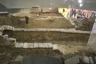
The oldest surviving colonial building in South Africa, the Castle of Good Hope, actually embraces two types of historic water provision. Built by the Dutch East India Company as a replenishment station for ships traveling between Europe and the East on expeditions, the fort had the vital role of providing fresh water for passing ships. A map from 1676 clearly illustrates the site’s proximity to various natural water courses, which provided the agricultural land and the fort with a constant supply of fresh water. The fort also possessed a system of wells and underground tunnels to manage this supply and to provide the city of Cape Town with fresh water, a second type of water provision. A well-known example is Wagenaer’s Reservoir, built in 1663 as an upgrade to Jan van Riebeeck’s dam system. Parts of the reservoir, including a brick channel that was built to drain the reservoir, still exist today.
Today we have maps to illustrate how rivers were used by settlements like Cape Town. In this regard, archives are of significant importance for the documenting and safeguarding of these maps. A recent transnational project, the creation of a scientific digital catalogue, aimed to make this shared cultural heritage better accessible.
Project
The Atlas of Mutual Heritage is a vast expanding database containing over 6244 images drawn from a variety of collections in the Netherlands and abroad, and linked to locational metadata. The mapped river courses and water systems of Cape Town can be examined within this atlas.

